Measuring the Shape of the Earth - 8 minutes read
In 1726 Voltaire faced a not very difficult choice: imprisonment without trial in the Bastille, or exile in England. After sailing across the Channel, he landed in another universe. Before leaving France, he declared, he had lived in a world that was full – but as soon as he arrived in England, he found one that was empty. It even looked different: ‘In Paris you see the Earth shaped like a melon; in London it is flattened on two sides.’ According to conventional French science, the Earth was stretched out, elongated so that its circumference around the Equator was shorter than around the poles. But Isaac Newton disagreed. Under his influence, English experts had come to hold the opposite view: that the Earth is squashed like a pumpkin, bulging out slightly in the middle.
The discrepancy between the two models was physically tiny: the Earth’s circumference is almost 25,000 miles, and Newton estimated that ‘the Earth will be higher at the equator than at the poles by an excess of about seventeen miles’. Far more was at stake than measurement, though. Getting it right was a matter of national honour that provided a crucial test for choosing between two conflicting ways of thinking about the natural world.
Cosmic warfare
To explain the root cause of this decades-long debate, Voltaire shifted into a more technical gear: ‘In Paris they see the universe as composed of vortices of subtle matter, in London they see nothing of the kind.’ He was referring to the contrasting theories of Europe’s two great scientific rivals, René Descartes and Isaac Newton. Whereas Newton envisaged planets hurtling through the vacuum of empty space, Descartes’ cosmos was crammed full of tiny invisible particles that perpetually swirled, sweeping the heavenly bodies along with them. A popular drinking song expressed the contest more colloquially:
Newton found out attraction, and prov’d nature’s void
Spite of prejudic’d Plenum’s constructions.
Gravitation can boast,
In the form of my toast,
More power than all of them knew, Sir.
Ironically, it had been a French discovery that originally inspired Newton to flatten the globe. A notoriously sedentary researcher who never even ventured across the Channel, Newton regularly appropriated observations sent in by merchant traders and other travellers. In the 1670s, while Newton was still developing the gravitational theories elaborated in his Principia Mathematica (1687), the astronomer Jean Richer noticed that his prized new clock kept losing time in South America and equatorial Africa: to make it work properly, he had to shorten the pendulum. To resolve this mystery, Newton suggested that gravity was weaker at the Equator than at the poles – that the surface of the Earth was further from its centre.
The arguments continued long after Descartes and Newton had both died. Eventually, with the support of Louis XV, Paris’ Royal Academy of Sciences decided to pour money into the problem and reach a definitive verdict. In the mid-1730s they sent out two expeditions: the first sailed south to what is now Ecuador, the second north to the Arctic Circle. Each team was instructed to measure the surface distance spanned by one degree of latitude: comparing the two results would immediately reveal any terrestrial deviation from a perfect sphere.
At least, that was the deceptively simple principle: unsurprisingly, real life refused to follow the script.
Problems in Peru
The first French Geodesic Mission set off for Peru in 1735. After stopping off in Haiti to pick up some enslaved Africans for the heavy work of lugging instruments up the sides of mountains, the group arrived in Quito a year later. Back in France, this had seemed the ideal destination: Africa was too dangerous, the Asian islands were too remote, and strengthening the political alliance between France and Spain promised backup against Britain as well as trading opportunities. Viewed from the other side of the Atlantic, the choice seemed less obvious, and the surveyors soon realised how unprepared they were for the challenges confronting them.
When sketched on paper, the Mission’s bid to measure a degree of latitude looks like a straightforward geometric exercise based on a chain of triangles snaking across the land for a couple of hundred miles. In practice, even getting started was a logistical nightmare. The first step was to dig a shallow trench seven miles long that had to be absolutely straight – easy to draw on a map, but far more difficult across hilly terrain. Getting this baseline right was crucial, as the subsequent measurements all depended upon it. The next stage was to single out a distant mountain peak as the apex of an imaginary triangle and measure the angles towards it from each end of the base line. Progressing from point to point, the same process had to be repeated many, many times; delightfully simple on a map, less so on the ground.
Month after month, the surveyors climbed volcanoes to heights never before reached by Europeans, waiting days for dense fogs to clear so they could make their observations. Having anticipated tropical jungles, they endured bitter cold, reporting: ‘Even with a pan alight with coals in our midst, and candles all around, the water froze in our very drinking glasses.’ Most were afflicted by the bleeding gums and vomiting that characterise altitude sickness, while their iron instruments also suffered – not helped by the fact that the tricky recalibration procedure demanded laying out a cord in a semicircle two miles across.
There were other setbacks as well. Like so many European travellers, they failed to anticipate the hostility of local people who had already suffered two centuries of Spanish occupation. Condemning Peruvian Indians as ‘barely distinguishable from beasts’, they forced their unwilling hosts into carrying out menial tasks instead of benefiting from their survival skills and cultural knowledge. They also argued among themselves and, after top-up funds failed to arrive from Paris, the group splintered. The final results were compiled by Charles-Marie de La Condamine, a mathematician who at one stage had been Voltaire’s partner in a lucrative scam to rig the national lottery, but was now becoming preoccupied with South American crops such as rubber and quinine.
Perhaps the cruellest blow of all fell after a couple of years – learning that the Arctic expedition had already arrived back in Paris and vindicated Newton. By the time La Condamine finally struggled home after a decade away, he had become yesterday’s news.
Arctic adventurers
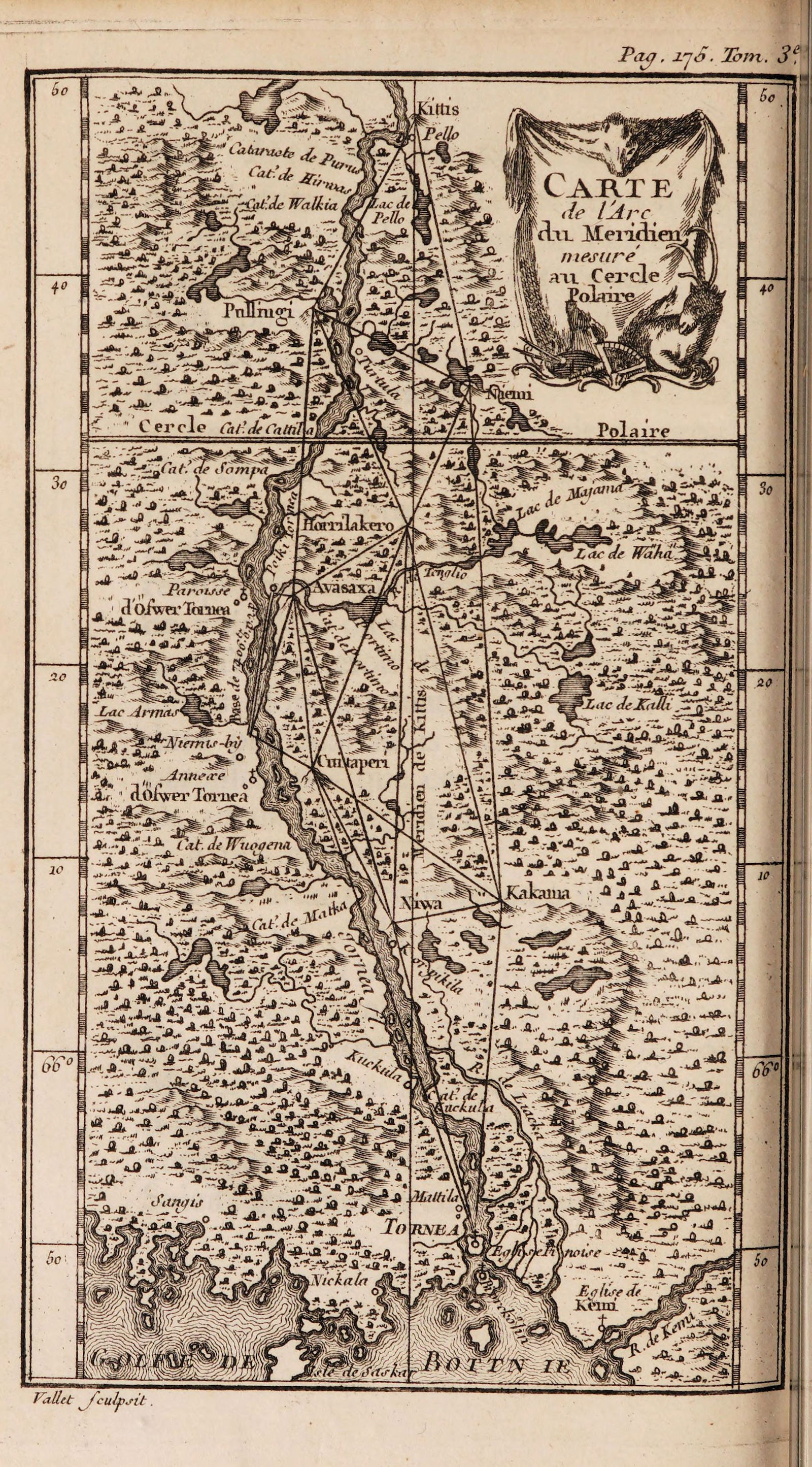
La Condamine had not even reached South America when the second French Geodesic Mission departed for northern Scandinavia under the leadership of Pierre Maupertuis. A staunch Newtonian, he soon returned, confirming the answer he had gone looking for.
Accompanied by several members of the Paris Academy as well as the Swedish astronomer Anders Celsius, now famous for his temperature scale, Maupertuis stopped off at Stockholm to be welcomed by the king before sailing north. Although he carried out the same type of triangulation survey as La Condamine, his project was less ambitious, covering about a quarter of the distance and taking only a few months to complete. After just over a year away, Maupertuis announced that a degree of latitude at the Arctic Circle was indeed considerably longer than one at Paris. Even though the results were less than clearcut, the Parisian scientific elite chose to accept his claim.
An ambitious young mathematician with a military background, Maupertuis was an inspired self-publicist who set about fashioning his reputation as a heroic French explorer. He commissioned a portrait, reproduced as engravings for wider dissemination, depicting a romantic traveller bundled up in furs and a quasi-Lapp costume as he squashes the globe beneath his hand. Like La Condamine and his colleagues, Maupertuis’ team endured appalling conditions, doing battle against fog, mosquitoes and freezing cold weather. But he turned these hardships into media opportunities, stacking the press with thrilling reports of his bravery in the frozen north and even producing anonymous satires lambasting his Cartesian opponents.
Anglo conversion
Maupertuis took advantage of the vogue for all things English that began sweeping across France and much of Europe in the 1730s. Voltaire had admired Newton during his London exile, but Maupertuis’ success nudged him into near obsession. He scattered compliments throughout his written work, and obliged guests to contemplate his bust of ‘the greatest genius that ever existed’.
Recognising a sales opportunity, a year after Maupertuis’ triumphant return Voltaire published a simplified primer on Newtonian optics and gravity. Yet although his name was on the title page, much of the work was carried out by Emilie du Châtelet, a wealthy aristocrat and superb mathematician. Whereas Maupertuis excelled at flamboyant showmanship, she provided the solid scholarship needed to convince all but the most recalcitrant Cartesians that it was time to convert.
Patricia Fara is an Emeritus Fellow of Clare College, Cambridge. Her most recent book is Life after Gravity: The London Career of Isaac Newton (Oxford University Press, 2021).
Source: History Today Feed